Paddock segmentation
SAM-based segmentation pipeline that turns a multi-temporal Sentinel-2
stack into a geopandas.GeoDataFrame of paddock polygons, with
area_ha, compactness, and a 1-based paddock integer ID.
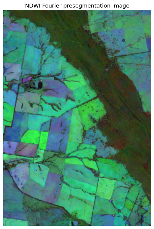
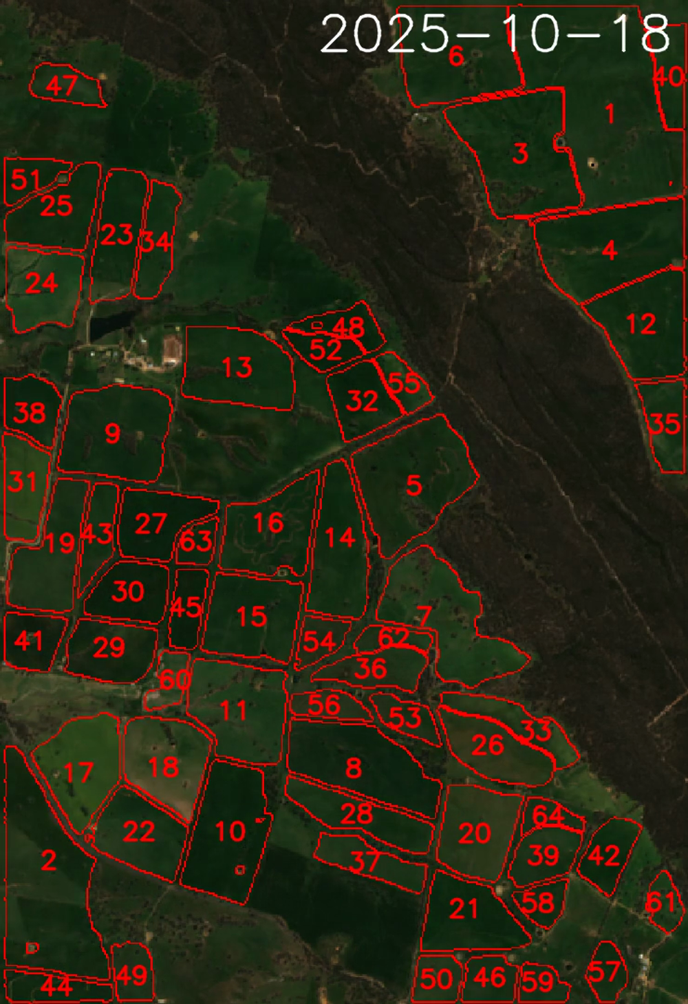
Three internal stages:
- Presegmentation — derives a single grayscale image from the
Sentinel-2 stack using NDWI Fourier features. This emphasises
stable field boundaries and suppresses transient noise (clouds,
shadows, seasonal greenness). Written as a GeoTIFF at
troi.preseg_path. - SAM mask generation — feeds the presegmented image to
segment-geospatial(samgeo). Default backbone is SAM ViT-H (sam_vit_h_4b8939.pth, ~2.4 GB) which is auto-downloaded on first use to{config.tmp_dir}/sam_weights. Outputs a mask GeoTIFF and a raw polygons GeoPackage. - Vectorisation and filtering — explodes multipart geometries,
reprojects to a local UTM zone for accurate area / perimeter,
computes
area_haand isoperimetriccompactness = 4πA/L², drops polygons outside[min_area_ha, max_area_ha]or belowmin_compactness, sorts by area descending, and assigns 1-basedpaddockIDs. Result written totroi.sam_paddocks_path.
Example: end-to-end with defaults
from datetime import date
from troi.troi import Troi
from PaddockTS.PaddockSegmentation.get_paddocks import get_paddocks

q = Troi(
    bbox=[148.36265, -33.52606, 148.38265, -33.50606],
    start=date(2024, 1, 1),
    end=date(2024, 12, 31),
    stub="seg_demo",
)

gdf = get_paddocks(q)         # downloads S2 first if needed
print(gdf[["paddock", "area_ha", "compactness"]].head())

#    paddock  area_ha  compactness
# 0        1   142.30         0.65
# 1        2    87.41         0.71
# 2        3    66.18         0.58
# ...

# Plot over a basemap
gdf.plot(facecolor="none", edgecolor="red", linewidth=1)
Example: tuning the filters
Defaults drop polygons under 5 ha, over 1500 ha, or below 0.1 isoperimetric compactness (sliver-like). For a high-resolution survey of small horticultural blocks:
gdf = get_paddocks(
    q,
    min_area_ha=0.5,      # keep small blocks
    max_area_ha=200,
    min_compactness=0.2,  # tighter shape filter
    device="cpu",         # force CPU even if CUDA available
)
For a broadacre survey where you want only large rectangular fields:
Example: visual sanity check against NDVI
To check segmentation quality, overlay the polygons on the median NDVI of the AOI to confirm boundaries follow real field edges.
import numpy as np
import matplotlib.pyplot as plt
from pysentinel2.cube import Cube

ds = Cube(config=q.config).get_ds_troi(q, indices=('NDVI',))
ndvi_median = np.nanmedian(ds['NDVI'].values, axis=0)
extent = [ds.x.min(), ds.x.max(), ds.y.min(), ds.y.max()]

fig, ax = plt.subplots(figsize=(10, 10))
ax.imshow(ndvi_median, cmap="RdYlGn", vmin=-0.1, vmax=0.9,
          extent=extent, origin="upper")
gdf.boundary.plot(ax=ax, color="red", linewidth=1)
ax.set_title(f"{len(gdf)} paddocks")
ax.axis("off")
Bring your own paddocks
If you already have field boundaries from QGIS, a cadastral layer, or
a previous run, skip SAM entirely. The downstream stages
(make_paddock_time_series, plotting) accept any
GeoPackage / Shapefile / GeoJSON with a paddock column. See
get_outputs(..., skip_sam=True, paddocks_filepath=...)
for the orchestrator-level option, or just pass the file directly:
from PaddockTS.Phenology.make_paddock_time_series import make_paddock_time_series

ts = make_paddock_time_series(
    q,
    paddocks_filepath="/path/to/my_paddocks.gpkg",
)
PaddockTS.utils.load_user_paddocks will add paddock, area_ha,
and compactness columns if your file is missing them.
Reference
PaddockTS.PaddockSegmentation.get_paddocks.get_paddocks 
get_paddocks(troi: Troi, ds_sentinel2=None, min_area_ha: float = 5, max_area_ha: float = 1500, min_compactness: float = 0.1, device: str | None = None) -> gpd.GeoDataFrame
End-to-end paddock segmentation: NDWI preseg → SAM masks → filtered polygons.
Caches each stage's output in the region x time cache
(:class:PaddockTS.paths.Paths): preseg.tif, sam_mask.tif,
sam_raw.gpkg, and the final sam_paddocks.gpkg — so reruns
and other stubs over the same bbox x dates reuse the work.
Parameters:
| Name | Type | Description | Default |
|---|---|---|---|
troi
|
Troi
|
The :class: |
required |
ds_sentinel2
|
Optional in-memory Sentinel-2 dataset. If |
None
|
|
min_area_ha
|
float
|
Minimum polygon area in hectares; smaller polygons are discarded as noise. Default 5 ha. |
5
|
max_area_ha
|
float
|
Maximum polygon area in hectares; larger polygons (typically the whole-AOI background mask) are discarded. Default 1500 ha. |
1500
|
min_compactness
|
float
|
Minimum isoperimetric compactness
|
0.1
|
device
|
str | None
|
Torch device for SAM. |
None
|
Returns:
| Type | Description |
|---|---|
GeoDataFrame
|
geopandas.GeoDataFrame: One row per paddock, sorted by |
GeoDataFrame
|
|
GeoDataFrame
|
|
GeoDataFrame
|
written to |